


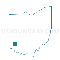
0064 HAR-T-S Voting District, Warren County, Ohio
About
Outline

Summary
| Unique Area Identifier | 652981 |
| Name | 0064 HAR-T-S Voting District |
| County | Warren County |
| State | Ohio |
| Area (square miles) | 14.32 |
| Land Area (square miles) | 14.32 |
| Water Area (square miles) | 0.00 |
| % of Land Area | 99.98 |
| % of Water Area | 0.02 |
| Latitude of the Internal Point | 39.28292720 |
| Longtitude of the Internal Point | -84.03480230 |
Maps


Graphs
Select a template below for downloading or customizing gragh for 0064 HAR-T-S Voting District, Warren County, Ohio


Neighbors
Neighoring Voting District (by Name) Neighboring Voting District on the Map
- 0062 HAR-T-M Voting District, Warren County, OH
- 0063 HAR-T-N Voting District, Warren County, OH
- 0104 HAR-T-W Voting District, Warren County, OH
- Voting District GOSHEN TOWNSHIP J, Clermont County, OH
- PRECINCT BLANCHESTER B, Clinton County, OH
- PRECINCT MARION, Clinton County, OH
- Voting District WAYNE TOWNSHIP A, Clermont County, OH
- Voting District WAYNE TOWNSHIP D, Clermont County, OH
- Voting District WAYNE TOWNSHIP E, Clermont County, OH
Top 10 Neighboring County Subdivision (by Population) Neighboring County Subdivision on the Map
- Goshen township, Clermont County, OH (15,505)
- Marion township, Clinton County, OH (5,394)
- Wayne township, Clermont County, OH (4,885)
- Harlan township, Warren County, OH (4,698)
Top 10 Neighboring Place (by Population) Neighboring Place on the Map
Top 10 Neighboring Unified School District (by Population) Neighboring Unified School District on the Map
- Little Miami Local School District, OH (29,636)
- Goshen Local School District, OH (15,754)
- Blanchester Local School District, OH (8,935)
Top 10 Neighboring State Legislative District Lower Chamber (by Population) Neighboring State Legislative District Lower Chamber on the Map
- State House District 66, OH (137,778)
- State House District 35, OH (128,703)
- State House District 88, OH (122,323)
- State House District 86, OH (114,338)
Top 10 Neighboring State Legislative District Upper Chamber (by Population) Neighboring State Legislative District Upper Chamber on the Map
- State Senate District 14, OH (380,921)
- State Senate District 7, OH (378,958)
- State Senate District 17, OH (360,811)
Top 10 Neighboring 111th Congressional District (by Population) Neighboring 111th Congressional District on the Map
Top 10 Neighboring Census Tract (by Population) Neighboring Census Tract on the Map
- Census Tract 401.01, Clermont County, OH (5,176)
- Census Tract 9649, Clinton County, OH (4,984)
- Census Tract 324, Warren County, OH (4,698)
- Census Tract 402.02, Clermont County, OH (2,177)